
Abu Dhabi scientists are trying to understand where threats from landslides or glacial collapses may emerge in Nepal as part of research that could save lives.
Their work may offer an early warning to communities at risk from floods prompted by landslides and glacier falls of the kind that last month killed more than 1,300 people and left thousands more missing.
Prof Mohammed Ali and Dr Aisha Al Suwaidi of the department of earth sciences at Khalifa University in Abu Dhabi are organising the project, which was set up before the recent tragedy, alongside University of Oxford researcher, Prof Mike Searle.

“If the work helps provide even a few additional minutes of warning, prevents unsafe development in a flood corridor, or improves understanding of where the next hazard may emerge, it will have considerable value,” Dr Al Suwaidi said.
Among the lessons that can be learnt from the recent disaster, the researchers said, is that events in a remote and sparsely populated location “can become a catastrophe much farther downstream”.
“Hazard assessment, therefore, has to follow the entire river system rather than stop at the glacier or national border,” Dr Al Suwaidi added.
The work is part of the Emirates Polar Programme, a research project looking at how the polar regions are being affected by climate change. The Himalayas are part of a region sometimes referred to as the third pole.
There is concern among scientists that the retreat of glaciers and the thawing of permafrost as a result of climate change will make landslides, glacial collapse and floods more likely.
United front
The scientists from Khalifa University are not the only people from the UAE working to help those in Nepal affected by the flooding tragedy.
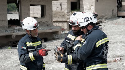
A UAE Search and Rescue team, working alongside Nepali personnel, have brought the total number of people recovered to 18 since their arrival in the country on September 4.
At least 1,385 have been killed in the floods, Nepal's National Disaster Risk Reduction and Management Authority said in its latest report. That toll is expected to rise, with 5,130 people still missing, while 13,600 have been rescued so far.
Before the disaster in Nepal, the scientists had started developing their research programme, planning field activities and recruiting researchers, including postgraduate students.
The work, to run over several years, will look at, for example, the region’s climate, changes to the cryosphere (ice, snow and permafrost), outburst floods from glacial lakes and tectonics or movements in the Earth's crust.

Early on, the researchers will analyse historical satellite observations to understand how the landscape has changed.
There will be repeated visits to the area, laboratory analysis and sustained observation of certain glaciers, slopes, lakes and rivers. “The programme brings together modern hazard monitoring and the geological reconstruction of past events,” Prof Ali said.
“This is important because a satellite image or river gauge can tell us what is happening now, whereas sediment and rock can show how frequently comparable events occurred over hundreds, thousands, or millions of years.”
Across the Himalayas in Nepal, glaciers, glacial lakes, snow cover, rivers, unstable slopes and landslide deposits will be mapped repeatedly.
Data from optical and radar satellites will help scientists determine how the area, height and speed of glaciers have changed. It will also help them understand how lakes have appeared and grown, and how landslides or ice dams have formed.
During last month’s disaster, a glacial collapse and a landslide were thought to have blocked a river, with vast quantities of water unleashed when the blockage was breached.
Extreme risk assessment
The devastation, some analysts said, highlighted the need to avoid building in areas at risk of extreme floods.
The importance of early-warning systems was shown by contrasting their absence in Nepal with their sophistication in Switzerland.
In May last year, after scientific analysis indicated that rock falls were putting stress on a glacier above the Swiss village of Blatten, the population was evacuated. Less than two weeks later, a glacial collapse and landslide destroyed the community.
As part of the new UAE research project, the scientists, with partners in Nepal, will select the most at-risk glaciers in need of detailed observations, saying it was not technically nor financially possible to monitor each one closely.

They will look for accelerated movement of ice, the development of fractures, changes in the levels of lakes, meltwater production and river discharge.
“Continuous monitoring remains sparse across much of Nepal,” Prof Ali said. “No instrument can guarantee that every collapse will be predicted. The purpose is to recognise abnormal changes where possible and to detect events quickly enough to warn downstream communities.”
Analysing, for example, lake sediment and previous deposits from floods and debris flows should provide evidence of former lakes, floods, landslides and earthquakes.
Of particular interest will be the Kathmandu and Pokhara valleys, the latter of which suffered severe flooding in 2012 that killed dozens after an avalanche created a temporary dam in the Seti river that later breached.
Chemical analysis of samples will show how rocks have been uplifted, exposed at the surface and eroded.
“Our goals are both scientific and practical,” Prof Ali said. “Scientifically, we want to understand how climate, glaciers, permafrost, rivers, erosion and tectonics interact across timescales ranging from individual flood events to millions of years.
“Ultimately, success would mean converting scientific observations into usable information: better maps, better monitoring, stronger local expertise, more effective warnings, and safer decisions about where and how infrastructure and communities are developed.”
Perhaps against expectations, the researchers said there was a direct physical connection between the area they were researching and the Arabian Peninsula.
“Dust transported over long distances can settle on Himalayan snow, reduce its reflectivity and increase its absorption of solar energy,” Dr Al Suwaidi said.
“Research has shown that dust can be a major contributor to the darkening and melting of high-altitude snow in high-mountain Asia, particularly above 4,000 metres.
“Some of that dust originates in arid regions of the Middle East, including the Arabian Peninsula. This means the UAE is not simply a distant observer of the third pole: our atmospheric and environmental systems are connected.”
Prof Searle, who is working with the UAE researchers on the project, has four decades of field experience in the Himalayas. He has collected samples while climbing mountains in the region.
He said the ultimate goal was to “understand the whole Himalaya ecosystem in detail” and to reduce the risk of disasters.
“It is very important to understand the whole cryosphere and the processes involved,” he said. “More than one billion people depend on water from the Himalaya. Glaciers are retreating, the permafrost that holds rocks together at altitude is melting. Landslides are becoming increasingly common and glacial lake outburst can be devastating.”
He said it was equally vital to understand the geology and tectonics – movements within the Earth’s crust – including how fast the mountains are uplifting, how rapidly the rivers are incising and, most importantly, the frequency and location of earthquakes.

