


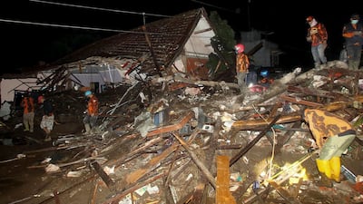
A powerful 7.4-magnitude earthquake struck eastern Indonesia on Tuesday triggering a tsunami warning, the meteorological department said, but there was no immediate word on any casualties or damage.
The quake struck at 0320 GMT in the Flores Sea, about 112km north-west of the town of Larantuka, in the eastern part of Flores island, at a depth of 12km.
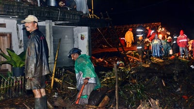
“Everyone ran out into the street,” Agustinus Florianus, a resident of Maumere town on Flores, told Reuters. Maumere was badly damaged by a quake of a similar magnitude in 1992.
Tsunami warnings were issued for the areas of Maluku, East Nusa Tenggara, West Nusa Tenggara and south-east and South Sulawesi.
The US Geological Survey said the quake had a magnitude of 7.3. An aftershock of 5.6 magnitude hit Larantuka after the first quake, the Indonesian agency said.
“It felt like a wave, up and down,” Zacharias Gentana Keranz, a resident of Larantuka told Reuters.
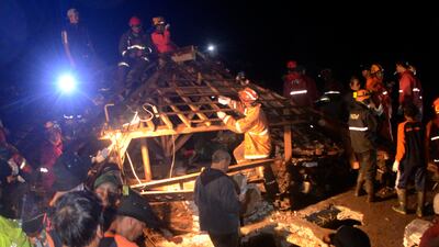
Alfons Hada Betan, head of East Flores Disaster Mitigation agency in Larantuka, said there were no immediate reports of damage and the quake was felt for several minutes as people left their homes.
People said on social media the earthquake was also felt strongly in Makassar, South Sulawesi.
-
Rescuers search for survivors following a flash flood in which at least five people were killed and four others reported missing in Malang, East Java, Indonesia. AFP -

According to the Indonesian National Board for Disaster Management, heavy rain triggered the flash flood. EPA -

Rivers on the slopes of Mount Arjuno overflowed their banks on Thursday and their muddy waters inundated five hamlets in Kota Batu. AFP -

Heavy rains are expected to continue and increase until February, partly because of a La Nina weather pattern. EPA -
Relief efforts were hampered by blocked roads covered with thick mud and debris. AP Photo -

Authorities were still collecting information about damage and possible casualties as they evacuated people in affected areas to government shelters. EPA -
Severe flooding was also reported in other areas of the country but no casualties were reported. AP Photo


The US-based Pacific Tsunami Warning Centre said, based on preliminary earthquake parameters, hazardous tsunami waves were possible for coasts located within 1,000km of the earthquake's epicentre.
Muhamad Sadly, an official with the meteorology agency, told Metro TV people should stay away from beaches, adding the tsunami warning would be lifted at least two hours after it was issued.
Indonesia straddles the “Pacific Ring of Fire”, an area of high seismic activity that rests on top of multiple tectonic plates.
At least 48 people were killed and hundreds injured when the Mount Semeru volcano erupted on Java island on December 4.