
A major weather front is expected to peak across the Gulf on Thursday and Friday, potentially bringing heavier rainfall, more thunderstorms and hail to parts of the UAE and surrounding areas.
The National Centre of Meteorology on Wednesday said the “final wave” of the current stormy weather was expected to develop from Thursday evening as the “low-pressure system deepens in the atmosphere”.
“It will then extend during Friday daytime to include northern regions, Al Ain and eastern areas, accompanied by heavy rainfall, lightning, thunder and possible hail in some limited areas,” before clearing later, the NCM said.

It comes after a week of heavy rain across the region. On Monday, Abu Dhabi and Ajman recorded near-annual totals, while 47.9mm fell on Das Island on Tuesday, with Abu Dhabi Corniche recording 28.3mm. Heavy rain continued to soak many parts of the UAE on Wednesday.
The Ministry of Human Resources and Emiratisation said the safety of the country's workforce was a “top priority” and urged companies to take precautionary steps to protect employees.
The General Authority of Islamic Affairs, Endowments and Zakat has urged worshippers to perform prayers at home while the unstable weather persists and Abu Dhabi Police urged delivery riders to steer clear of the roads for their own safety.
-
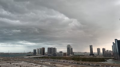
Clouds over Abu Dhabi, as seen from Reem Island. Gareth Cox / The National -

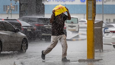
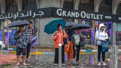
A man walks with an umbrella as heavy rain hits Sharjah. Ahmed Ramzan / The National -
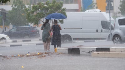
Heavy rain fell across the UAE while safety alerts were issued over more adverse weather to come. Ahmed Ramzan / The National -
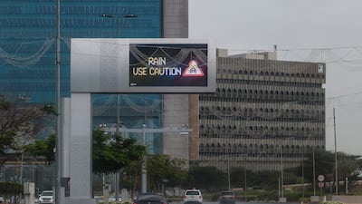
Another day of heavy rain and flooding in central Abu Dhabi as the National Centre of Meteorology forecast downpours, thunder and windspeeds of up to 55kph for March 25. Victor Besa / The National -

After two days of torrential downpours, residents in the capital were preparing for the rain with waterproof clothing or the ever-reliable umbrella. Victor Besa / The National -
In Sharjah City at Clock Tower roundabout, this resident improvised with a reusable plastic bag to keep the rain off. Antonie Robertson/The National -

Some residents who braved the rain in Sharjah City chose to move as fast as they could through the raindrops. Antonie Robertson/The National -

Birds of a feather gather as the rain falls in Satwa, Dubai. Chris Whiteoak / The National -

Covering your property from the rain in Satwa, Dubai. Chris Whiteoak / The National


Residents also began preparing their homes against any potential floods.
International forecasters reported a chance of tornadoes in the Middle East generally, though these are highly unusual and far less severe than typical US weather systems.
“The strength of tornadoes varies even within the US,” Jason Nicholls, lead international forecaster for AccuWeather, told The National. “Any tornado in the UAE would likely be on the lower end of the scale, most likely an EF0 or EF1,” he said, referring to the Enhanced Fujita Scale that measures tornado intensity, with EF5 the most severe.
Long-term trend
More broadly, experts say the current spell could indicate a possible shift in weather patterns towards more persistent and intense downpours, raising questions about how the arid region manages stormwater.
Diana Francis, head of Khalifa University's Environmental and Geophysical Sciences (Engeos) laboratory in Abu Dhabi, told The National: “When we talk about the persistence and increasing intensity of these events, we mean a pattern where a series of storms affects the same area over several days, arriving one after the other and becoming stronger over time.”
“Here, ‘intensity’ refers to how much rain falls in a short period – millimetres per hour – so even if total rainfall is similar, faster, heavier bursts have a much greater impact and significantly increase the risk of flooding and disruption.”
She said these intense bursts can overwhelm drainage networks, leading to flooding while also reducing the chance for the water to soak into the ground meaning instead of recharging aquifers, most of the water becomes run-off.
“Intense rainfall is now a real and recurring risk, even in arid regions,” she said. “This is why these events increase flood risk without significantly improving long-term water availability.”
She said there was much countries could do to prepare, such as upgrading drainage systems, adding temporary storage such as flood channels and designing cities so they could absorb water.
Other ways include using dams to store water and capturing stormwater through aquifer-recharge systems. Better forecasting, risk planning and early-warning systems are also crucial.
“The key shift is moving from: ‘this is unusual weather’ to ‘this is a risk we need to design for’.”
-

People in Abu Dhabi and other cities woke up to heavy rain. Victor Besa / The National -

Most parts of the UAE were experiencing heavy rain and thunderstorms for a second day. Victor Besa / The National -
More wet weather was forecast for the rest of the week. Victor Besa / The National -
Wet conditions in central Abu Dhabi. Victor Besa / The National -

Catching a bus in the capital. Victor Besa / The National -

A woman captures views of the Abu Dhabi Corniche with her phone. Victor Besa / The National -

Umbrellas to the rescue. Victor Besa / The National -
Large puddles form in Dubai Sports City after heavy rain. Chris Whiteoak / The National -
Grey skies in Dubai Sports City. Chris Whiteoak / The National


Looking ahead to prediction
Dr Mohamed Dawoud, senior water adviser at the Environment Agency Abu Dhabi, told The National there are changing weather patterns that authorities are studying.
“We are studying this [to be able] to predict the rainfall intensity and frequency in the next 50 years [and] to modify even our infrastructure to be able to receive this stormwater in the next 50 years.”
Dr Dawoud said one pattern had been more rain in March and April rather than January and February, which has typically been the case in the past 20 years.
“[There is the change in] in the frequency, the change in the intensity, the change in the duration and timing, and the volumes received. All these changes need to be discussed and need to be modelled.”