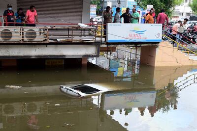
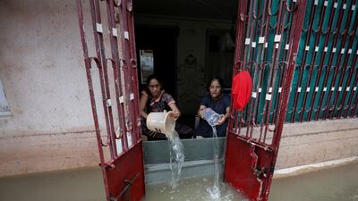
The unprecedented rainfall that killed at least 500 people in flooding and landslides across India since the onset of this year’s monsoon is symptomatic of climate change and global warming, experts say.
India has been in the grip of the south-west monsoon — the rainy season, which lasts from June to September and provides 75 per cent of the country’s annual rainfall.
The rains irrigate more than half of India’s farmland and are crucial for its agriculture sector, which contributes about 20 per cent of GDP.
While flooding occurs in some areas every year, this monsoon has caused havoc from north to south and from east to west.
The north-eastern states of Assam and Meghalaya have received the highest rainfall in 120 years for June. More than 300 people have been killed in rain-related incidents in Assam and more than 78,000 livestock have perished. Hundreds of thousands of people have been affected by flooding in 30 of the state’s 35 districts.
Telangana in the south, Odisha in the east, and the western states of Gujarat and Maharashtra have all been hit by days of torrential showers.
In Maharashtra, more than 100 people died as a result of heavy rains that affected all but seven of its 35 districts.
Nearly 12,000 people have been shifted to relief camps, while at least three districts — Ratnagiri, Gadchiroli and Wardha — remain on alert as rivers are in spate.
The state altogether received nearly one-and-a-half times more rain than the average for the first half of July — 392.7mm compared with 162mm.
Neighbouring Gujarat, a state known for its arid weather, received half of its average seasonal rainfall in 24 hours on July 11.
Nearly 100 people have died in rain-related incidents in the state, while eight districts were completely inundated.
The districts of Chhota Udepur, Panchmahal, Tapi, and Ahmedabad were in a rain deficit between June 1 and July 10 but then received excess rain over a short period of time, triggering flash floods and waterlogging in vast stretches of the city.
Chota Udepur received 330mm of rain in 24 hours, while the Saurashtra region received more than 200mm on July 15.
More than 40,000 people have been moved to safer places, while several parts of Gujarat remain inundated.
Manorama Mohanty, director of the Indian Meteorological Department's Gujarat unit, said the state had received an average of 70 per cent excess rainfall this year.

“I have never seen rain like this in my whole life here,” said Umesh Gavit, 27, a resident of the tribal-dominated Dang district. “It was unusual … terrifying.”
Weather experts and climate activists say India’s monsoon pattern has been changing over the past decade.
They said the reason for such heavy showers this year is that the "monsoon trough" — the movement of the monsoon —was faster than usual and reached unusual areas.
“This is abnormal,” said Mahesh Palawat, vice president of Skymet private weather forecaster.
vice president of private weather forecaster Skymet
“Gujarat and south Rajasthan were known to be arid regions but now three-digit rainfall is very common. Vidarbha and Marathwada in Maharashtra were drought-prone areas where rainfall was patchy but this year we have seen excess rainfall,” Mr Palawat said.
He said the number of rainy days was shrinking, even though the total amount of rain was almost the same.
“Rainfall that happened in three to four days is happening in 24 hours,” he said.
Soumya Dutta, a climate activist and convenor of the Climate and Energy Group, also blamed the record heatwave that blanketed parts of the country for four months since March.
Mr Dutta said the heatwave pumped large amounts of extra moisture into the higher atmosphere.
When the monsoon winds came, the monsoon trough moved at a very high speed and arrived in western regions even before showering northern areas like Delhi and Uttar Pradesh, which are facing a rain deficit.
“This time the heat was unusually high because of the heatwaves; the anomaly was over 4-6 degrees [Celsius] The Arabian Sea and Bay of Bengal were much warmer than usual and pumped more moisture this year,” Mr Dutta said,
He said that as the moisture was deposited for a longer time, when the monsoon front travelled, large amounts of moisture was carried and was dumped within a few hours.
“The fast wind which normally takes two weeks, it took 4 to 5 days,” Mr Dutta said.
The activist said that due to climate change, such anomalies will increase.
“This kind of anomaly is happening repeatedly, but this is just the beginning – the way we are going, this will be very normal in the next 10-15 years,” he said.


