Historical, cultural and natural sites from across Lebanon are now available to over a billion Google users worldwide after the launch of a special project bringing its Street View technology to the country.
Google Street View Special Collects, which operates as part of Google Maps, lets users virtually explore landmarks and natural wonders from their phones or computers. To view highlights of the Lebanon collection, which includes sites such as the Beirut Corniche, Jeita Grotto and the Shouf mountains, click here.
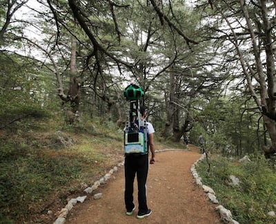
Data for the project was captured by the Google Maps team using a "Trekker", a backpack-mounted camera weighing 18kg designed to get to locations down footpaths, tracks and narrow pathways that can't be reached by cars, taking pictures every few metres. It also has motion sensors to track its position, a hard drive to store data, a small computer running the system, and lasers to capture the 3D data to determine distances. It can also go inside buildings. A spokesperson for Google said that after collection, "the imagery is stitched together to create the 360° panoramic images that allow you to move around and explore locations as if you were there." The project has involved consultation with the Ministry of Culture, Ministry of Tourism and other parties.
A spokesperson for Google said they had chosen Lebanon for the project "to provide people from all over the world with the most comprehensive and accurate imagery of this important historic and touristic location" and because it is "beautiful, diverse and authentic." "Through the imagery, we hope to inspire a deeper appreciation for this special country and encourage travellers to start their next adventure in Lebanon and we look forward to putting more of Lebanon on Street View for the world to explore the country's rich heritage and culture."
At a time when many travellers are avoiding Lebanon for security reasons, the data allows people to see the country before visiting, or planning for a later visit. Some of the sites are less well known and more out of the way than others, and these include Chekka, south of Tripoli, the World Heritage Site of Tyre, in the far south of the country, the Ibrahim River and Beaufort Castle, close to the Israeli border.
Today, anyone with an internet connection can virtually explore the natural landscape of Lebanon including tourist sites such as the Jeita Grotto and Al Shouf Cedar Nature Reserve, learn
about the country's history from Baalbek and the Temple of Jupiter the Black Castle Château du Liban, the spectacular Sea Castle of Sidon and Niha fortress. The imagery also includes heritage sites and universities, including the Nicolas Sursock Palace, Roman baths and the American University of Beirut.
Lebanon is the latest addition to a series of Street View Special Collects in MENA, such as Petra in Jordan, the Amphitheatre of El Jem in Tunisia, Burj Khalifa in Dubai, the Sheikh Zayed Grand
Mosque in Abu Dhabi and the Pyramids of Giza in Egypt. Street View is currently available in 10 Arab cities including Dubai, Sharjah, Ajman, Ras Al Khaimah, Umm Al-Quwain,
Fujairah, Tunis, Ramallah, Bethlehem and Jericho.
Google Maps Street View began in 2007 and today covers thousands of cities. The program has also captured 360 degree imagery of theme parks, university campuses, pedestrian malls,
landmarks and zoos around the world.
___________
Read more:
Google reveals UAE's most popular travel search queries
How we book travel - the view from Google Dubai
Where to go in 2018: trending destinations for trips from the GCC
___________


