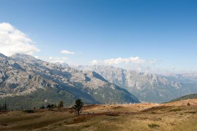
The Peaks of the Balkans is an epic long-distance trekking route, through the mountainous borderlands of Montenegro, Albania and Kosovo. Over a distance of 192 kilometres it meanders along remote valleys and over high passes, taking in some of the finest scenery this ruggedly beautiful corner of Europe has to offer.
The trail was set up by the German development agency GIZ in conjunction with local tourist offices and hiking clubs, the idea being to encourage sustainable tourism in this mountainous region (known as Prokletije, which translates as “the Accursed Mountains”) and help create an income for the local population. In the short number of years since it was established, the trail has welcomed a steady increase in hikers, and several villagers have opened small guesthouses along the route.
The route involves slipping backwards and forwards over the borders between these three countries, and you do still need a permit to hike the trail. This is easy enough to get however – local trekking agencies will do the paperwork for you, for a small fee. Either Zbulo in Albania (www.zbulo.org) or Zalaz in Montenegro (www.zalaz.me) are the best agencies to go through – both were involved in setting up the trail from the beginning. They can also arrange accommodation, transfers or guides if you want. You can also apply for the permit yourself, although it takes a bit more patience.
I first visited Prokletije about 15 years ago, staying in an old mountain hut and doing several hikes in the Grbaja Valley, surrounded by breathtaking, spiky peaks with evocative names such as Fang and The Spear. One day I hiked up the neighbouring Ropojana Valley, a long, broad ribbon of green climbing ever so slightly towards the border with Albania.
The weather had closed in, the surrounding peaks and saw-toothed ridges were wreathed in cloud. But it was still a profoundly beautiful place. Mist swept across the valley, and the only people we met that day were a few young Albanian children gathering wild berries, their laughing faces stained red. In the 15 years since that visit, the Prokletije mountains have become a national park (Montenegro's fifth, and still its least visited), and the trail along the floor of the Ropojana Valley has become part of the Peaks of the Balkans.
There’s a lake at the head of the Ropojana Valley, or at least there was on that first visit – it’s fed only by snowmelt, and as a subsequent visit confirmed, has a habit of vanishing, phantom-like, into the ground. In any case, the far side of the cold grey lake – or lush green grass-covered lakebed, depending on the season – marks the border with Albania.
Once this valley formed a trade route between the Theth Valley in Albania and Plav in what is now Montenegro. It’s easy enough to get here now – there are about five buses a day to Plav from the Montenegrin capital, Podgorica – but in the late 19th century, on the crumbling fringes of the Ottoman Empire, this was a spectacularly remote and difficult spot to reach. The intrepid English traveller Edith Durham had to travel in disguise when she was here in the early 1900s, and described the nearby village of Gusinje as the Lhasa of Europe on account of its inaccessibility.
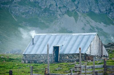
Hiking up the Ropojana Valley last year, while researching a guidebook to the Peaks of the Balkans, the weather was no less bleak. I slipped into Albania in a veil of mist, climbing up through forest to the pastures at Fusha e Ruinices, where two simple shelters used by shepherds during the summer months stand beside a spring.
Farther up into the mountains I passed a couple of the half a million or so concrete bunkers built by Albania’s former Communist leader Enver Hoxha between the 1960s and the 1980s. Now they are slowly being reclaimed by the landscape, the narrow slits of their loopholes watching over the valley like empty eyes.
Higher still I pass a deep-set lake surrounded by boulders the size of houses – and then I find myself on the Peje Pass, overlooking the Theth Valley. The path down follows a well-engineered track above a giddying abyss – the north face of the peak on the right, Maja Harapit, falls in a sheer drop of about 800 metres. Somewhere near the base of that cliff is the entrance to Albania’s longest known cave system, which stretches over two and a half kilometres under the mountain. Once down in the valley I join a rough 4x4 track through the scree, then in the early evening light walk down farm lanes overhung with fruit trees, to arrive at Bujtina Polia, a lovely, welcoming guesthouse in the village of Theth.
The following morning I head down the valley to the Grunas waterfall, an easy 45-minute walk away. Families are picnicking on the rocks, beside an emerald-green pool, with the waterfall tumbling over 30 metres down the cliff behind them.
Then from Theth I continue along the Peaks of the Balkans, hiking through forest and ascending steeply to the Valbona Pass, on the watershed between the Valbona and Theth valleys. The sun breaks out on the vast wall of rock that is Maja e Boshit, streaks of green forest cling to the sides of the Valbona Valley, and over to the north the summit pyramid of Maja Jezerces, at 2,694 metres the highest mountain in Prokletije, is framed within a halo of cloud.
Since the route of the Peaks of the Balkans was laid out, there have been several changes to the trail on the ground, which have not yet been incorporated into the official map.
One is the stage between Valbona and Ceremi, which “officially” goes along an asphalt road for several kilometres, then after a short section on a rickety path, along a 4x4 track – hardly making for a very exciting day of mountain walking. Any local guide however will tell you that the best hiking route from Valbona to Ceremi is over the Prosllopit Pass – a notch on the horizon, on the border ridge between Albania and Montenegro.
____________________
Read more:
12 new UAE flight routes for 2018
New women-only adventures around the world
Tour du Mont Blanc: a grand tour of the Alps
____________________
I set off early the next morning, the trail clear enough and right opposite the guesthouse in Valbona where I'd spent the night. The path climbs steeply to pastures and an old shepherd's hut, then through old-growth forest and meadows carpeted in wild flowers, the air filled by clouds of tiny blue butterflies. It takes me about four hours to reach the Prosllopit Pass, a grassy swath surrounded by limestone crags beneath a lowering sky.
This is not a day for climbing Maja Kolata (Montenegro's highest mountain), about 500 metres above me on my right – the barometer on my watch suggests there's a storm coming, and I aim to get off this high ground quickly.
After stopping briefly for something to eat – succulent cucumber, tangy white sheep’s cheese and a great slab of village bread – I loop down into Montenegro slightly, then uphill once more to the Borit Pass, and down into Albania again.
It’s late afternoon when I finally arrive at the Kujtim Gocaj Guesthouse in Ceremi, a tiny village at the head of the valley, where I am greeted by a warm welcome, a phenomenally good dinner, and endless, tulip-shaped glasses of hot tea.
The Peaks of the Balkans is an outstanding route through breathtaking and little known mountain scenery, which still attracrts only a fraction of the number of hikers of Europe’s better-known mountain ranges. It’s an opportunity to experience genuine rural hospitality. And it’s accompanied by a feeling – rarely encountered in Europe these days – of somehow slipping off the map.


