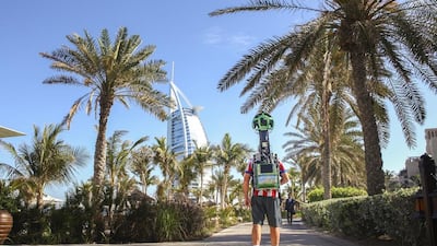
DUBAI // To mark the UAE’s 45th National Day, Google has launched a 360-degree view of more than 40 iconic Dubai sites, allowing people around the world to take a digital tour of Dubai Mall, Deira Spice Souq and other landmarks.
Users can now see the sites via Street View, a feature on Google Maps that allows users to view and navigate 360-degree imagery of streets across the world.
The imagery was launched in Street View Special Collects, a feature of Google Maps that allows users to explore landmarks, natural wonders, as well as culturally and historically significant sites all over the world.
Ulf Spitzer, global lead for the Google Street View programme, said: “We are excited about this wave of Special Collects, especially now as people all over the country prepare to mark the UAE’s 45th National Day.
“Street View has been in Dubai since 2013, with Burj Khalifa being the first Special Collect in the UAE. Now users can visit other locations such as the Dubai Aquarium and Underwater Zoo, take a stroll through The Dubai Mall and the historic Deira Spice Souq, among others.”
This is the latest in a series of Street View imagery of major landmarks in the region, with Petra in Jordan, Sheikh Zayed Grand Mosque in Abu Dhabi, and the Pyramids of Giza in Egypt available to view.
To achieve this, Google had to equip street-roamers with the Street View camera, which normally captures the images from on top of a car. The roamers wear a backpack that prompts them to walk around, stop every few metres and capture a 360-degree street-level photo.
The technology has motion sensors to track its position, a hard drive to store data, a small computer running the system and lasers to capture 3D data to determine distances in the Street View imagery.
After collection, the imagery is stitched together to create the 360-degree panoramic images that allow you to move around and explore locations as if you were there.
To visit, users can go to maps.google.com
newsdesk@thenational.ae

