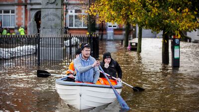
Flooding has hit parts of Northern Ireland and Ireland as police advised people against travelling in the heavy rain before the expected arrival of Storm Ciaran on Wednesday.
More than 25 flood warnings have been issued for the UK, with Storm Ciaran also forecast to bring strong winds and heavy rain to parts of England and Wales.
A weather alert is in place for eastern France from Wednesday, with three regions expecting violent storms as wintry weather starts to bite.
Parts of Newry in Northern Ireland were under water on Tuesday after the city's canal burst its banks. Roads have been closed across the region.
“We had to break into the shop to get in because if you opened the front door you'd let more water in, so we broke windows and got in to get the stock that was dry, and get it upstairs,” shop owner Paul McCartan said. “Other stock is saturated.”
Police have advised people to avoid Newry city.
Flooding on railway tracks caused disruption to train services on the main cross-border Belfast to Dublin route on Tuesday.
South of the border, there was flooding on main roads including the N1 motorway in Co Louth.
A 24-hour rain warning for Co Kerry in the south-west is in place from noon on Tuesday.
The UK Met Office has issued amber weather warnings for much of the south coast of England on Thursday as Storm Ciaran threatens to batter parts of the country.
Strong north-westerly winds could disrupt travel and damage buildings.
Gusts are likely to reach 110kph-130kph in some areas and may exceed 135kph in a few of the most exposed English Channel coastal spots.
Meteorologists predict the most severe conditions on Wednesday night into Thursday.
Met Office meteorologist Clare Nasir said Storm Ciaran was “likely to be a notch down” in intensity from Storm Babet, but flooding could still occur because the ground is “so laden with water” and river levels “are at their highest”.
Ms Nasir said the storm would affect southern areas of the UK on Wednesday evening as it approaches, as well as on Thursday morning during rush hour before it tracks northwards.
“We could see some coastal flooding because the winds will be so strong, particularly initially across more southern areas,” she added.
“It's not a fast-moving system, so it's going to be with us for at least two and a half, if not three days and most places will be impacted in some shape or form by this storm.”
France has placed three north-east regions – Finistere, Morbihan and Cotes-d'Armor – on alert, while another weather warning is in place for all of eastern France.
Strong winds, coupled with persistent heavy rainfall, are expected, leading to potential flooding and further complications in areas already hit by recent storms.
Residents are urged to be vigilant and keep updated with the latest forecasts and warnings. The emphasis is on avoiding coastal paths, promenades and refraining from driving through floodwater to ensure public safety.


